Fil:UN Partition Plan For Palestine 1947.png
Hopp til navigering
Hopp til søk

Størrelse på denne forhåndsvisningen: 327 × 598 piksler. Andre oppløsninger: 131 × 240 piksler | 627 × 1 147 piksler.
Opprinnelig fil (627 × 1 147 piksler, filstørrelse: 65 KB, MIME-type: image/png)
Beskrivelse
| Beskrivelse |
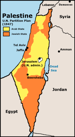
English: UN 1947 partition plan for Palestine |
|||
| Dato | ||||
| Kilde | Crop and edit of http://www.lib.utexas.edu/maps/historical/israel_hist_1973.jpg, Scan from “Issues in the Middle East”, Atlas, U.S. Central Intelligence Agency, 1973. | |||
| Opphavsperson | U.S. Central Intelligence Agency | |||
| Tillatelse (Gjenbruk av denne filen) |
According to lib.utexas.edu here and here, the map is “produced by the U.S. Central Intelligence Agency, unless otherwise indicated.” There is no such mark with this map, so it is presumed the map is PD-US-GOV. | |||
| Andre versjoner |
|


Lisensiering
This work is in the public domain in the United States because it is a work prepared by an officer or employee of the United States Government as part of that person’s official duties under the terms of Title 17, Chapter 1, Section 105 of the US Code.
Note: This only applies to original works of the Federal Government and not to the work of any individual U.S. state, territory, commonwealth, county, municipality, or any other subdivision. This template also does not apply to postage stamp designs published by the United States Postal Service since 1978. (See § 313.6(C)(1) of Compendium of U.S. Copyright Office Practices). It also does not apply to certain US coins; see The US Mint Terms of Use.
|
 | |
| Denne filen har blitt identifisert til å være fri for kjente restriksjoner under lov om opphavsrett, inkludert alle relaterte og nærstående rettigheter. | ||
Orginal opplastningslogg
The original description page was here. All following user names refer to en.wikipedia.
- 2005-09-22 08:54 Doviende 627×1147× (71732 bytes) added label for Jordan River
- 2005-09-22 08:45 Doviende 627×1147× (67165 bytes) Map showing the 1947 UN partition plan for palestine. inspired by [[User:JamesDay]]'s similar image, but redone from the source with better fonts and non-fuzzy colors Copyright: GFDL derivative work created by the uploader based on a portion of the publ
- 2003-10-02 12:45 Jamesday 306×557× (10448 bytes) Map showing the 1947 UN partition plan for Palestine
Filhistorikk
Klikk på et tidspunkt for å vise filen slik den var på det tidspunktet.
| Dato/klokkeslett | Miniatyrbilde | Dimensjoner | Bruker | Kommentar | |
|---|---|---|---|---|---|
| nåværende | 19. mar. 2015 kl. 19:03 | | 627 × 1 147 (65 KB) | wikimediacommons>Foghe | Borders |
Filbruk
Det er ingen sider som bruker denne filen.