Fil:Northern and Southern Ireland.png
Hopp til navigering
Hopp til søk
Ingen høyere oppløsning tilgjengelig.
Northern_and_Southern_Ireland.png (415 × 541 piksler, filstørrelse: 14 KB, MIME-type: image/png)

|
Dette bildet bør gjenskapes med hjelp av vektorgrafikk som en SVG-fil. Dette har flere fordeler, se Commons:Media for cleanup for mer informasjon. Hvis en SVG-fil med dette bildet er tilgjengelig, vennligst last den opp. Etter opplasting erstatt denne malen med {{vector version available|nytt bilde.svg}}.
|
Beskrivelse
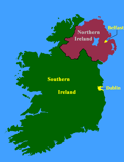
from english wikipedia(21:56, 15 August 2005 . . JW1805 . . 415x541 (14825 bytes)) Map of Northern Ireland and Southern Ireland, created by the Government of Ireland Act, 1920
Lisensiering

|
The copyright holder of this work allows anyone to use it for any purpose including unrestricted redistribution, commercial use, and modification.
Usage notes:
|
Filhistorikk
Klikk på et tidspunkt for å vise filen slik den var på det tidspunktet.
| Dato/klokkeslett | Miniatyrbilde | Dimensjoner | Bruker | Kommentar | |
|---|---|---|---|---|---|
| nåværende | 26. des. 2005 kl. 14:28 | | 415 × 541 (14 KB) | wikimediacommons>Ideru~commonswiki | from [http://en.wikipedia.org/wiki/Image:Northern_and_Southern_Ireland.pngenglish wikipedia](21:56, 15 August 2005 . . JW1805 . . 415x541 (14825 bytes)) Map of Northern Ireland and Southern Ireland, created by the Government of Ireland Act, 1920 |
Filbruk
Den følgende siden bruker denne filen: