Fil:Korean war 1950-1953.gif
Hopp til navigering
Hopp til søk
Størrelse på denne forhåndsvisningen: 387 × 600 piksler. Andre oppløsninger: 155 × 240 piksler | 562 × 871 piksler.
Opprinnelig fil (562 × 871 piksler, filstørrelse: 1,32 MB, MIME-type: image/gif, gjentas, 20 rammer, 30 s)
Beskrivelse
| Beskrivelse |
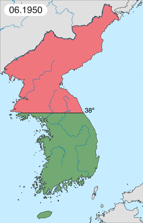
Deutsch: Karte des Koreakriegs von Mai 1950 bis Juli 1951, abgebildet:
English: Map of Korean war from May 1950 to July 1951, showing:
Chinese and communist forces (Soviet Union) (light red) North Korean forces (red) South Korean, US and United Nations forces (green). Français : Carte de la guerre de Corée de mai 1950 à juillet 1951, montrant:
Les forces chinoises et communistes (Union Soviétique) (rouge clair) Les forces nord-coréennes (rouge) Les forces sud-coréennes, des États-Unis et des Nations unies (vert). Italiano: Mappa della guerra di Corea dal maggio 1950 al luglio 1951, rappresentante:
Le forze cinesi e comuniste (Unione Sovietica) (rosso chiaro) Le forze nord-coreane (rosso) Le forze sud-coreane, degli Stati Uniti e delle Nazioni Unite (verde). |
| Dato | |
| Kilde | Eget verk |
| Opphavsperson | Leomonaci98 |
Lisensiering
Jeg, rettighetsinnehaver av dette arbeidet, publiserer det herved under følgende lisenser:

|
Det tillates at dette dokumentet kopieres, distribueres og/eller modifiseres under retningslinjene som beskrevet i GNU fri dokumentasjonslisens, versjon 1.2 eller senere utgave utgitt av Free Software Foundation; med alle seksjoner, uten noen forsidetekster og baksidetekster. En kopi av lisensen er inkludert i avsnittet GNU Free Documentation License. |
| Denne filen er lisensiert under lisensen Creative Commons Navngivelse-DelPåSammeVilkår 3.0 Unported | ||
| ||
| Dette lisensmerket ble lagt til filen som del av lisensoppdateringen av GFDL. |
Du kan velge lisens etter eget valg.
Filhistorikk
Klikk på et tidspunkt for å vise filen slik den var på det tidspunktet.
| Dato/klokkeslett | Miniatyrbilde | Dimensjoner | Bruker | Kommentar | |
|---|---|---|---|---|---|
| nåværende | 16. feb. 2020 kl. 22:20 | | 562 × 871 (1,32 MB) | wikimediacommons>Leomonaci98 | Graphic update |
Filbruk
Den følgende siden bruker denne filen: