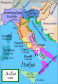
Fil:Italy 1000 AD.svg

Opprinnelig fil (SVG-fil, standardstørrelse 565 × 811 piksler, filstørrelse: 861 KB)
Denne filen er fra Wikimedia Commons og kan brukes av andre prosjekter. Beskrivelsen fra filbeskrivelsessida vises nedenfor.
Beskrivelse
| BeskrivelseItaly 1000 AD.svg |
English: Political map of Italy in 1000 AD (CE). Created by MapMaster.
Part of a series of maps on the history of Italy:
|
| Dato | 17. november 2006 (original upload date) |
| Kilde | No machine-readable source provided. Own work assumed (based on copyright claims). |
| Opphavsperson | Ingen maskinlesbar opphavsperson oppgitt. MapMaster er antatt opphavsperson, basert på opplysninger om opphavsrett. |
| Andre versjoner |
[rediger] SVG:
PNG:
|
Denne SVG-fila inneholder tekst som enkelt kan oversettes til andre språk. Lær mer. For SVG-bilder kan du benytte [toolforge:svgtranslate/File:Italy_1000_AD.svglink denne sida] for å oversette teksten til et annet språk. |
References
- Bjorklund, Oddvar; Holmboe, Haakon; Rohr, Anders (1970) Historical Atlas of the World, Barnes & Noble, NY, SBN: 389-00253-4.
- This map from Allyn & Bacon, Longman, textbook publishers.
- This map of the w:en:Holy Roman Empire
- A map from Attilios
- This map of 1050 AD Italy, from the 1923 The Historical Atlas by William R. Shepherd
- This map of 1000 AD Italy from Fordham University, adapted from Muir's Historical Atlas, (1911).
In addition, a number of other sources were consulted in an effort to determine the following matters:
- The extent of Venetian control over the cities of Dalmatia such as Zara and Spalato. Although the Venetians had been pushed off the mainland earlier, in the period around the year 1000, the Venetians made an effort to recover these cities.
- The extent of Saracen control over Corsica and Sardinia. Information is sparse. The apparent situation is that the Muslims had several bases on the coasts of these islands, but did not control the countryside (such as they did in Sicily).
- Whether or not the principalities of Capua and Benevento were separate states in the year 1000. Based on lists of their rulers (various Pandulfs and Landulfs), the answer seems to be "yes".
- Who controlled the Balkans on the southeastern border of the Kingdom of Croatia. Candidates include Bulgaria, the Byzantine Empire, Croatia, and Serbia.
As noted, there is significant disagreement among sources on these questions.
This map was commissioned by Attilios, and there is also a discussion to be found on MapMaster's English talk page.
Lisensiering

|
Det tillates at dette dokumentet kopieres, distribueres og/eller modifiseres under retningslinjene som beskrevet i GNU fri dokumentasjonslisens, versjon 1.2 eller senere utgave utgitt av Free Software Foundation; med alle seksjoner, uten noen forsidetekster og baksidetekster. En kopi av lisensen er inkludert i avsnittet GNU Free Documentation License.http://www.gnu.org/copyleft/fdl.htmlGFDLGNU Free Documentation Licensetruetrue |
| Denne filen er lisensiert under lisensen Creative Commons Navngivelse-DelPåSammeVilkår 3.0 Unported | ||
| ||
| Dette lisensmerket ble lagt til filen som del av lisensoppdateringen av GFDL.http://creativecommons.org/licenses/by-sa/3.0/CC BY-SA 3.0Creative Commons Attribution-Share Alike 3.0truetrue |
derivative works
Derivative works of this file: Italya MS 1000.svg
Bildetekster
Elementer som er med i denne fila
motiv
17. nov. 2006
image/svg+xml
Filhistorikk
Klikk på et tidspunkt for å vise filen slik den var på det tidspunktet.
| Dato/klokkeslett | Miniatyrbilde | Dimensjoner | Bruker | Kommentar | |
|---|---|---|---|---|---|
| nåværende | 17. apr. 2007 kl. 21:50 |  | 565 × 811 (861 KB) | wikimediacommons>MapMaster | Some further changes |
Filbruk
Den følgende siden bruker denne filen:


