Fil:Ireland.svg
Hopp til navigering
Hopp til søk

Størrelse for denne PNG-forhåndsvisningen av denne SVG-filen: 471 × 599 piksler Andre oppløsninger: 188 × 240 piksler | 377 × 480 piksler | 603 × 768 piksler | 804 × 1 024 piksler | 1 609 × 2 048 piksler | 2 200 × 2 800 piksler.
Opprinnelig fil (SVG-fil, standardstørrelse 2 200 × 2 800 piksler, filstørrelse: 204 KB)
Beskrivelse
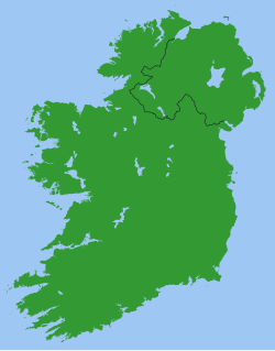
Map of Ireland, with North-South boundary delimited.
SVG should be fairly easy to alter or expand. For example the following can all be achieved with one-line CSS changes:
- You can toggle the Northern Ireland border on/off or change its thickness
- You can change any of the colours
- You can draw a border around all the land to make it more distinct from the sea
- You can hide Northern Ireland or the Republic of Ireland.
You can also do any of the following just by changing or adding/removing a few lines of SVG code:
- Zoom in on Northern Ireland, the Munster shoreline, or any other area
- Remove all the small islands (e.g. for faster rendering)
- Add drop shadows (feGaussianBlur), textured ground (feTurbulance) or topography (feDisplacementMap + feSpecularLighting)
- Add cities and towns.
- Add rivers. Anyone care to do this?
Originally derived from Image:Lough-Neagh.svg.
Lisensiering
| Jeg, opphavsrettensholderen til dette verket, frigir dette verket til allmennheten. Dette gjelder på verdensbasis. I enkelte land kan dette være juridisk umulig. I så fall: Jeg gir hvem som helst retten til å bruke dette verket for ethvert formål, uten noen vilkår, med mindre slike vilkår kreves ved lov. |
s]]
Filhistorikk
Klikk på et tidspunkt for å vise filen slik den var på det tidspunktet.
| Dato/klokkeslett | Miniatyrbilde | Dimensjoner | Bruker | Kommentar | |
|---|---|---|---|---|---|
| nåværende | 13. mar. 2007 kl. 23:49 | | 2 200 × 2 800 (204 KB) | wikimediacommons>Nickshanks | increased default size, modified lough Erne |
Filbruk
Den følgende siden bruker denne filen: