Fil:Indo-European branches map.png


|
En vektorversjon av dette bildet (SVG) er tilgjengelig.
Det bør brukes i stedet for punktgrafikkbildet når det er fordelaktig. File:Indo-European branches map.png → File:Indo-European branches map.svg
For mer informasjon om vektorgrafikk les Commons transition to SVG. Se også information about MediaWiki's support of SVG images. |
 |
Beskrivelse
| Beskrivelse |
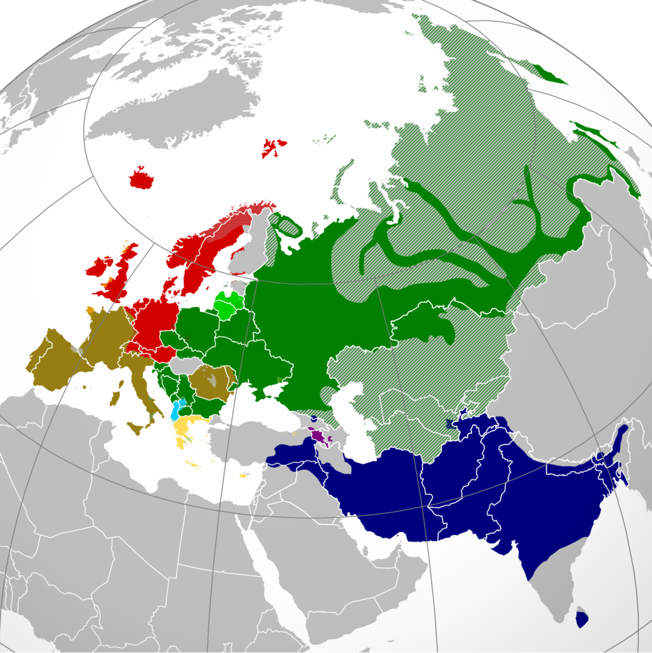
English: A map showing the approximate present-day distribution of the Indo-European branches within their homelands of Europe and Asia. The following legend is given in the chronological order of the earliest surviving written attestations of each branch:
Non-Indo-European languages
Dotted/striped areas indicate where multilingualism is common (more visible upon full enlargement of the map). |
||
| Dato | |||
| Kilde |
For the names of the branches, see citations in legend (based on "Indo-European Languages". The College of Liberal Arts. UT Austin. 2008.) and "Indo-European languages" from Britannica.com. The distribution is essentially and approximately based on the map "Indo-European languages – Approximate locations of Indo-European languages in contemporary Eurasia" from Britannica.com, although with the following minor modifications: The two articles "Balto-Slavic languages" and "Indo-Iranian languages" from Britannica.com stress the lack of scholarly consensus on these branches. That is, for the former, whether Baltic and Slavic developed from a common ancestral language, or that the similarities are the result of parallel development and of mutual influence during a long period of contact. To cater for both scholarly viewpoints, this map shows Baltic and Slavic with two distinct shades of green under "Balto-Slavic". For the latter, the dispute is whether the Indo-Iranian languages include just the Iranian and Indo-Aryan (or, Indic) language groups, or Nūristānī and Bangani too. To prevent disagreement (and also because this map only represents the primary branches of Indo-European), all of Indo-Iranian is represented with one shade. The article "Romance languages" from Britannica.com states that the Romance languages form "a subgroup of the Italic branch of the Indo-European language family". It should be noted that this map is only approximative and simplified, and glosses over some multilingual areas (particularly in eastern Russia, which is difficult to represent accurately). For some areas, more regional maps have been used as sources for greater accuracy, namely "Languages of Switzerland" from Ethnologue.com, "Russia ethnic plurality" from Freelang.net, "Major ethnic groups in Central Asia" from Globalsecurity.org, and "South Asian Language Families" from "Language families and branches, languages and dialects in A Historical Atlas of South Asia". Oxford University Press. New York 1992. |
||
| Opphavsperson | Hayden120 | ||
| Tillatelse (Gjenbruk av denne filen) |
Jeg, rettighetsinnehaver av dette arbeidet, publiserer det herved under følgende lisenser: Denne filen er lisensiert under lisensene Creative Commons Navngivelse-DelPåSammeVilkår 3.0 Unported, 2.5 Generisk, 2.0 Generisk og 1.0 Generisk.
Du kan velge lisens etter eget valg. |

Filhistorikk
Klikk på et tidspunkt for å vise filen slik den var på det tidspunktet.
| Dato/klokkeslett | Miniatyrbilde | Dimensjoner | Bruker | Kommentar | |
|---|---|---|---|---|---|
| nåværende | 7. jun. 2024 kl. 09:28 | | 2 934 × 2 938 (1,91 MB) | wikimediacommons>Golden | update Karabakh |
Filbruk
Den følgende siden bruker denne filen: