Fil:Huns empire.png
Hopp til navigering
Hopp til søk

Størrelse på denne forhåndsvisningen: 800 × 458 piksler. Andre oppløsninger: 320 × 183 piksler | 640 × 366 piksler | 998 × 571 piksler.
Opprinnelig fil (998 × 571 piksler, filstørrelse: 186 KB, MIME-type: image/png)
Beskrivelse
| Beskrivelse |
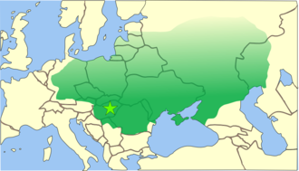
Español: El imperio huno se extendía desde las estepas de Asia Central hasta la actual Alemania, y desde el Danubio hasta el Báltico
This is a map of the empire of Attila the Hun, circa 450 CE (AD),skettenploetskpoe jok odern borders. The borders of Attila's empire are only approximate because:
|
||
| Dato | 7. november 2004 (original upload date) | ||
| Kilde | No machine-readable source provided. Own work assumed (based on copyright claims). | ||
| Opphavsperson | Ingen maskinlesbar opphavsperson oppgitt. .:Ajvol:. er antatt opphavsperson, basert på opplysninger om opphavsrett. | ||
| Andre versjoner |
|

References
- Bjorklund, Oddvar; Holmboe, Haakon; Rohr, Anders (1970) Historical Atlas of the World, Barnes & Noble, NY, SBN: 389-00253-4.
- Man, John, (2006) Attila: The Barbarian King Who Challenged Rome, Thomas Dunne Books, New York.
- Shepherd, William (1911) "The Roman and Hunnic Empires about 450", Historical Atlas. New York: Henry Holt and Company.
Lisensiering
| Jeg, opphavsrettensholderen til dette verket, frigir dette verket til allmennheten. Dette gjelder på verdensbasis. I enkelte land kan dette være juridisk umulig. I så fall: Jeg gir hvem som helst retten til å bruke dette verket for ethvert formål, uten noen vilkår, med mindre slike vilkår kreves ved lov. |
Filhistorikk
Klikk på et tidspunkt for å vise filen slik den var på det tidspunktet.
| Dato/klokkeslett | Miniatyrbilde | Dimensjoner | Bruker | Kommentar | |
|---|---|---|---|---|---|
| nåværende | 20. aug. 2018 kl. 02:49 | | 998 × 571 (186 KB) | wikimediacommons>Logger in denial | Reverted to version as of 04:44, 14 November 2006 (UTC) |
Filbruk
Den følgende siden bruker denne filen: