Fil:Greyfriars, Leicester site.gif
Hopp til navigering
Hopp til søk

Størrelse på denne forhåndsvisningen: 758 × 600 piksler. Andre oppløsninger: 303 × 240 piksler | 607 × 480 piksler | 970 × 768 piksler | 1 280 × 1 013 piksler | 1 655 × 1 310 piksler.
Opprinnelig fil (1 655 × 1 310 piksler, filstørrelse: 651 KB, MIME-type: image/gif)
Beskrivelse
| Kameraposisjon | | Dette og andre bilder på denne posisjonen på: OpenStreetMap |
|---|
| Beskrivelse |
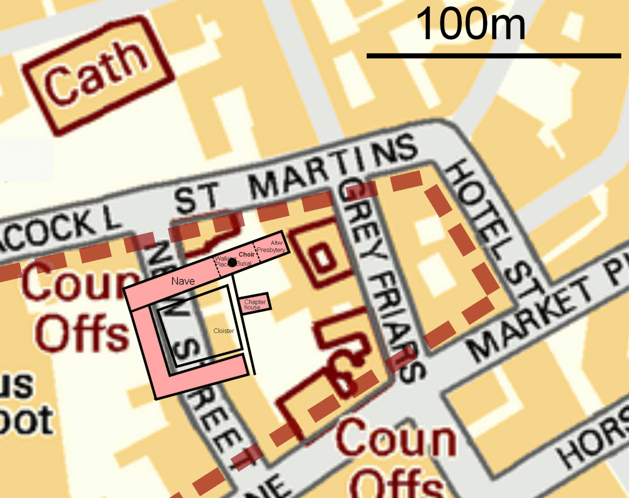
English: Leicester Greyfriars Church site map.
Map is OSGB36 with the Church Choir suggested to be at SK58550438. The dotted brown line indicates the area Billson, 1920, identified as the extent of the Greyfriars grounds. The University of Leicester 2012 dig has posited the Church, Chapter House, Cloisters and monastic buildings as the pink area shown, with a black dot indicating the location of the grave which contained the remains of Richard III. |
| Dato | |
| Kilde | Base map OS OpenData VectorMap District. Greyfriars perimeter from Billson, C. J., 1920, Medieval Leicester, facing p. 1. Edgar Backus, Leicester (Archive.org). Greyfriars Church details, University of Leicester Plan of the 2012 Archaeological dig, Mail Online, 12 Sept 2012 |
| Opphavsperson | RobinLeicester based on sources described. |
Lisensiering
This file is licensed by the Ordnance Survey of the United Kingdom under their OS OpenData License
In short: you are free to distribute and modify the file as long as you attribute (including year), the Ordnance Survey. Navngivelse: Contains Ordnance Survey data © Crown copyright and database right (year) Note: Derivative works can be licensed under any Creative Commons Attribution 3.0 Licence. |
.svg)
|
This file is licensed under the United Kingdom Open Government Licence v3.0. |
See also: Meta for information on usage on Wikimedia wikis.
|
svg version

|
En vektorversjon av dette bildet (SVG) er tilgjengelig.
Det bør brukes i stedet for punktgrafikkbildet når det er fordelaktig. File:Greyfriars, Leicester site.gif → File:Greyfriars, Leicester site.svg
For mer informasjon om vektorgrafikk les Commons transition to SVG. Se også information about MediaWiki's support of SVG images. |
 |
Filhistorikk
Klikk på et tidspunkt for å vise filen slik den var på det tidspunktet.
| Dato/klokkeslett | Miniatyrbilde | Dimensjoner | Bruker | Kommentar | |
|---|---|---|---|---|---|
| nåværende | 5. feb. 2013 kl. 18:27 | | 1 655 × 1 310 (651 KB) | wikimediacommons>Soerfm | Dot |
Filbruk
Den følgende siden bruker denne filen: