Fil:Druckorte Inkunabeln.svg

Opprinnelig fil (SVG-fil, standardstørrelse 1 843 × 1 995 piksler, filstørrelse: 1,72 MB)
Denne filen er fra Wikimedia Commons og kan brukes av andre prosjekter. Beskrivelsen fra filbeskrivelsessida vises nedenfor.
Beskrivelse
| BeskrivelseDruckorte Inkunabeln.svg |
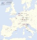
Deutsch: Verbreitung des Buchdrucks im 15. Jahrhundert dargestellt anhand der Druckorte von Inkunabeln. 271 Druckorte sind bekannt, die größten sind mit Namen versehen. Die Daten beruhen auf dem Incunabula Short Title Catalogue der British Library (Stand 2. März 2011). Die Gewässerdarstellung entspricht dem heutigen Stand.
English: Printing places of incunabula showing the spread of printing in the 15th century. 271 locations are known, the largest of them are designated by name. The data is based on the Incunabula Short Title Catalogue of the British Library (as of March 2, 2011). Bodies of water correspond to present state.
Français : Diffusion de l'imprimerie au XVe siècle représentée par les lieux d'impression des incunables. 271 lieux d'impression sont connus, les plus grands ont des noms. Les données sont basées sur le Incunabula Short Title Catalogue de la British Library (au 2 mars 2011). La représentation de l'eau correspond à l'état actuel.
Español: Difusión de la imprenta en el siglo XV representada por los lugares de imprenta de incunables. Se conocen 271 lugares de imprenta en el siglo XV, las más grandes tienen nombres. Los datos se basan en el Incunabula Short Title Catalogue de la British Library (a partir del 2 de marzo de 2011). La representación del agua corresponde al estado actual. |
|
| Dato | ||
| Kilde | ||
| Opphavsperson |
|
|
| Tillatelse (Gjenbruk av denne filen) |
Denne filen er lisensiert under lisensen Creative Commons Navngivelse-DelPåSammeVilkår 3.0 Tyskland.
 Denne filen er lisensiert under lisensen Creative Commons Navngivelse-DelPåSammeVilkår 3.0 Unported
|
|
| Andre versjoner |
|

|
This map has been made or improved in the German Kartenwerkstatt (Map Lab). You can propose maps to improve as well.
azərbaycanca ∙ čeština ∙ Deutsch ∙ Deutsch (Sie-Form) ∙ English ∙ español ∙ français ∙ italiano ∙ latviešu ∙ magyar ∙ Nederlands ∙ Plattdüütsch ∙ polski ∙ português ∙ română ∙ sicilianu ∙ slovenščina ∙ suomi ∙ oʻzbekcha / ўзбекча/ ∙ македонски ∙ русский ∙ ქართული ∙ հայերեն ∙ বাংলা ∙ ไทย ∙ +/−
|
Orginal opplastningslogg
This image is a derivative work of the following images:
- File:Europe_laea_location_map.svg licensed with Cc-by-sa-3.0
- 2010-03-10T19:40:39Z Alexrk2 1401x1198 (2313185 Bytes) +San Marino, enh. coastline & countries
- 2010-03-10T18:44:00Z Alexrk2 1401x1198 (1521812 Bytes) == Summary == {{Information |Description= {{de|Positionskarte [[:de:Europa|Europa]]; Politisch mit Staatsgrenzen, Inlandgewässer; Flächentreue Azimutalprojektion}} {{en|Location map [[:en:Europe|Europe]]; Political with sta
Bildetekster
Elementer som er med i denne fila
motiv
11. jul. 2011
Filhistorikk
Klikk på et tidspunkt for å vise filen slik den var på det tidspunktet.
| Dato/klokkeslett | Miniatyrbilde | Dimensjoner | Bruker | Kommentar | |
|---|---|---|---|---|---|
| nåværende | 4. sep. 2012 kl. 19:25 |  | 1 843 × 1 995 (1,72 MB) | wikimediacommons>NordNordWest | upd |
Filbruk
Metadata
Denne filen inneholder tilleggsinformasjon, sannsynligvis lagt til av digitalkameraet eller skanneren som ble brukt til å lage eller digitalisere det.
Hvis filen har blitt forandret fra utgangspunktet, kan enkelte detaljer være unøyaktige.
| Bredde | 1842.5px |
|---|---|
| Høyde | 1994.832px |

