Fil:1904 Map showing Little Russia and South Russia.pdf
Hopp til navigering
Hopp til søk

Størrelse for denne JPG-forhåndsvisningen av denne PDF-filen: 560 × 600 piksler Andre oppløsninger: 224 × 240 piksler | 562 × 602 piksler.
Opprinnelig fil (562 × 602 piksler, filstørrelse: 3,44 MB, MIME-type: application/pdf)
Beskrivelse
| Beskrivelse |
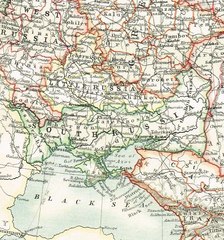
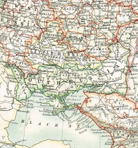
English: 1904 Map showing boundaries of Little Russia and South Russia. |
| Dato | |
| Kilde | 1904 atlas by W.& A.K. Johnston "The World-Wide Atlas" |
| Opphavsperson | Photo by Paul Hundal |
Lisensiering
This media file is in the public domain in the United States. This applies to U.S. works where the copyright has expired, often because its first publication occurred prior to January 1, 1930, and if not then due to lack of notice or renewal. See this page for further explanation.
|
 | |
 |
Filhistorikk
Klikk på et tidspunkt for å vise filen slik den var på det tidspunktet.
| Dato/klokkeslett | Miniatyrbilde | Dimensjoner | Bruker | Kommentar | |
|---|---|---|---|---|---|
| nåværende | 8. feb. 2015 kl. 18:49 |  | 562 × 602 (3,44 MB) | wikimediacommons>Paulhundal | User created page with UploadWizard |
Filbruk
Den følgende siden bruker denne filen: